Teachers
GCSE AQA 3.1.1 · 15 minutes · no login
Continental drift
All teacher notes · Open the lab · 2125 words · ·
Why this lesson, and why the 3D
Continental drift is a fifteen-minute projector lesson, not a homework packet and not a film with a quiz bolted on. Put this hook on the board before you dim the lights: 250 Ma the pieces fit. Fossils agree. The ocean is not a static floor continents plough through. By the end of the slot a pupil should be able to scrub 250 Ma to now, toggle fossil/fit overlay, and treat Pangaea as the same plates earlier. Curriculum tags in the header (GCSE AQA 3.1.1; NGSS MS-ESS2-3) are filters, not a flag. The room is worldwide; SI first; International English. Ages on the card (KS3, GCSE, NGSS MS) are a suggested band, not a gate.
A GCSE class that still thinks continents plough a static ocean will misread Iceland, the Himalaya, and every earthquake map that follows. The United Kingdom is not a plate. It rides the Eurasian plate. The Mid-Atlantic Ridge at Iceland is where that plate is born, a few centimetres per year, with a country sitting on the split. San Andreas is the United States pair: the Pacific and North American plates slide past, so California’s hazard is transform motion, not a continent chewing through a frozen Pacific. Wegener’s coast fit and matching fossils across the young Atlantic are the evidence. Plates are the mechanism he did not have. Himalaya collision is the same machine stacking crust that Iceland makes at a ridge. If the ocean floor were static, those fossils would be a miracle and India would have no walk north into Eurasia. News maps that freeze today’s beaches as eternal outlines hide 250 million years of passengers. Treat Pangaea as the same plates at an earlier time, not a mythic first Earth.
The 3D is a named, inspectable object. Click the part, not a caption. If the model will not spin, the Why panel still carries the mechanism, the two photographs, and the film. Do not apologise for the model. Drive it. A silent spin teaches a screensaver. A named mesh that changes under a slider teaches the process.
Fifteen minutes on the projector
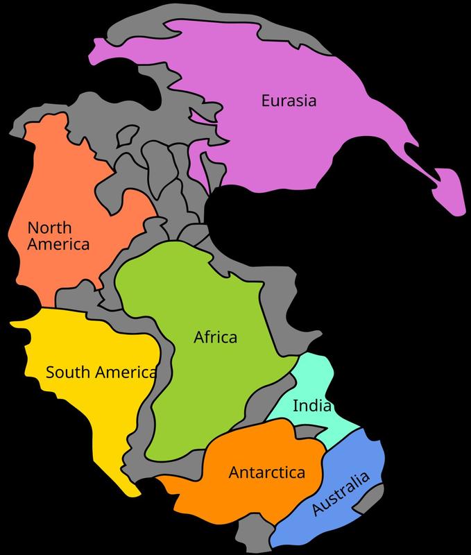
Set Ma before present to 250 Ma. The pieces fit. Toggle Fossil / fit overlay on. Fossils and the shelf edge are the evidence. Fit continental shelves, not today’s beaches. Scrub toward now. India walks north. Pangaea is a late Palaeozoic–Mesozoic supercontinent, not Earth’s starting position, and not the only one. Continents do not plough a static ocean. Both are plate. They are passengers. Ocean floor is plate too. Wegener had the fit. Plates are the mechanism. Name Iceland (makes crust), Himalaya (stacks it), San Andreas (slides). The United Kingdom rides Eurasia. It is not a plate. Pause near 0 Ma and name what changed. Finish in Check.
Open the lab full screen (F). Labels on (L). Speak the first step before you touch a slider: Pangaea. Fit the coasts. Then the second: Scrub to now. India walks north. Then the third: Fossils and fit are evidence. Plates are the mechanism.
The sliders that earn their keep are Ma before present ( Ma); Fossil / fit overlay. Space plays; arrows nudge time; R resets. Parameters the URL can remember: ageMa, fossils. If you only have eight minutes, skip the last step and finish in Check. Projector layout (P) is for the back row: one idea, large type, the model still live.
Set the Ma before present slider to 250 Ma. The pieces fit. Toggle Fossil / fit overlay on so matching fossils and the shelf argument read from the back row. When paused, that slider is the clock; Space play overrides it and walks Pangaea to now. Left and right arrows nudge time. Watch India walk north as the Atlantic widens. L toggles labels. R resets to the lab defaults. P switches projector mode. E explode and X slice do nothing here: this is a globe of passengers, not a cut apple. Pause near 0 Ma and name what changed.
The in-site film is “Pangaea” (Khan Academy, about 6 min, Khan Academy on YouTube. CC BY-NC-SA. Educational embed, autoplay off.). Autoplay is off. Play one minute if you need a second voice; do not let the film eat the slot. The 3D still has to move under your hand.
What the third row will get wrong
You will hear the misconception before you have finished the first sentence. Write the false claim on the board and leave it there until the model has contradicted it. Do not skip this. A fluent pupil can recite the hook and still believe the false sentence.
“Continents plough through static oceans.” — no. Both are plate.
“Pangaea was Earth’s first crust, and the only supercontinent.” — no. It is a late Palaeozoic–Mesozoic assembly, not a starting position, and not the only one.
“You fit today’s beaches to prove drift.” — no. Fit continental shelves. The holiday sand is not the outline.
Pitfalls to keep in your pocket: Pangaea as the only supercontinent. Fitting today’s beaches instead of continental shelves. Calling the United Kingdom a plate. It rides Eurasia. Drawing the ocean as a static floor continents plough through. Do not let a pupil leave thinking the 3D is a photograph. It is a teaching model. Where vertical exaggeration exists, T collapses it and the caption says so. A labelled lie of scale is honest. An unlabelled one is a cartoon.
Two places, not a slogan
Continents are passengers on lithospheric plates. Oceanic lithosphere is plate too: born at ridges, destroyed at trenches. From about 300 to 180 Ma a supercontinent, Pangaea, sat assembled. It was not Earth’s starting position and not the only supercontinent in the record. After it rifted, the Atlantic opened. India walked north and stacked into Eurasia as the Himalaya. Wegener argued fit, fossils, and palaeoclimate; he lacked a driving mechanism. Seafloor spreading and subduction supply it. Fit the continental shelves, not today’s beaches: the real outline is the shelf edge, the shallow submerged margin. Matching fossils across South America and Africa sit on crust that was once adjacent. The United Kingdom was already a Eurasian passenger. San Andreas did not yet cut California as it does now. The model’s labelled lie is the cartoon you are looking at. Continents are extruded polygons. Motion is a straight interpolation from 250 Ma to the present. Two hundred and fifty million years play in one lesson. Real plate paths curve, rotate, and include microplates this scene omits. The globe is a teaching sphere, not a palaeogeographic reconstruction you could navigate. Fossil matches are dots, not assemblages. What remains true: the pieces fit at the shelf, the Atlantic is young, India has moved north, and neither continent nor ocean is a static stage.
The first place to land is Iceland. The second is San Andreas. Same process, different rock or climate. If a pupil can only name one place, they have a postcard, not a mechanism. Atlas entries for those names are a click from the case list; send them back to the lab with one sentence they can say in Check.
Do not flatten the comparison into “this country versus that country.” Name the landform. Holderness is till, not chalk. Hawaii is a hotspot, not an island arc. Yosemite is a glacial trough, not a river canyon. The 3D is allowed to be schematic; the place names are not allowed to be sloppy.
Figures and the film
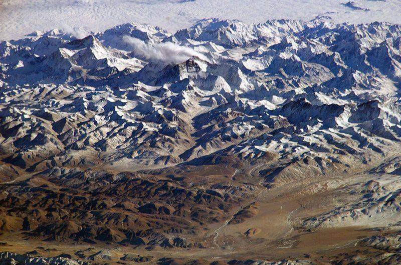
Field photograph: Collision mountains where a continent arrived. A continent that walked. Credit: NASA / public domain.
Mechanism photograph: Field or official figure for teaching Continental drift. A second photograph for the projector script — not the lab cover. Credit: Wikimedia Commons / NASA / USGS.
Two photographs, two jobs. The field picture is the place. The mechanism picture is the process. Do not run the lesson on a single Apollo Earth disc. A carbon-cycle class is a forest and a seam, not a blue marble. An ENSO class is a Pacific temperature map, not Africa from Apollo 17.
Words they must be able to say
Say these out loud once while you click the matching mesh. If a word has no mesh, it still has a photograph in Terms.
Pangaea: Supercontinent ~300–180 Ma. Not the first, not the only, not Earth’s starting position. Continental shelf: Shallow submerged margin. Fit this edge, not today’s beaches. Lithosphere: Crust plus the rigid top of the mantle. Plates are lithosphere, not crust alone. Continental drift: Wegener’s description of moving continents. Plates are the mechanism he lacked. Seafloor spreading: New oceanic crust at a ridge. Ocean floor is plate too, born and later destroyed. Subduction: Oceanic plate consumed at a trench. The conveyor’s far end. Supercontinent: An assembly of most continents. Pangaea is one of several in Earth history. Shelf fit: Matching continents at the shelf edge. Beaches are a Holocene disguise. Exam language also accepts “Continental reconstruction”.
Exam-language toggle (the Teacher tab) swaps UK/US pairs where they exist — levée/levee, arête/arete — so a mixed room is not punished for spelling.
Close the slot
Without the 3D view the lesson still holds. At about 250 Ma the continental shelves fit as Pangaea. Matching fossils across the South Atlantic are the evidence; plates are the mechanism. Continents do not plough a static ocean: both are plate. Iceland makes crust at a ridge. The Himalaya stacks it at collision. San Andreas slides. The United Kingdom rides Eurasia. Kola never cored this history; we reconstruct it from fit, fossils, and the ocean floor. If JavaScript is off you still have the caption, the glossary, and Check. Draw two outlines, fit the shelves, then pull them apart. That sketch is the model.
Finish in Check — ten questions, not a mood. The bank mixes definition, process, the misconception you just killed, a named place, and a read-the-model item (click the part; T). If a pupil can only recite the hook, they have not used the geometry. Wrong answers still show the one-line explain. Do not skip the explain.
Sources on the Teacher tab are the trail, not a bibliography to copy. USGS plates; BGS.
Link back to the live lab and keep the same slug. Do not invent a parallel worksheet that contradicts T, SI, or the named parts.
This note is worldwide. Curriculum tags (GCSE AQA 3.1.1; NGSS MS-ESS2-3) are filters, not a flag. A class in Nairobi, London, or Shanghai can use the same 3D. Ages (KS3, GCSE, NGSS MS) are a suggested band. If a sentence only works in one exam board, rewrite it before you project it.
Write these three lines on the board before you dim the lights. One: 250 Ma the pieces fit. Fossils agree. The ocean is not a static floor continents plough through. Two: the misconception “Continents plough through static oceans.”. Three: the named parts they must click. Then drive the model. Check is ten questions covering definition, process, the misconception, a place, and a read-the-model item. Do not skip the explain on a wrong answer.
Board, units, and what not to say
SI first. Metres, kilometres, degrees Celsius, metres per second. A conversion in brackets is courtesy, not a second system. Do not let a pupil leave thinking the 3D is a photograph. It is a teaching model. Where vertical exaggeration exists, T collapses it and the caption says so.
Do not say “teaching mesh”, “sprinkle”, or “thin free surface not a fat pipe” out loud. Say the landform. Seasons are ~23.44° of axial tilt, not Earth–Sun distance. The outer core is liquid; S-waves do not pass. Yosemite is a glacial U-trough. San Andreas is a transform. Hawaiʻi and Yellowstone are hotspots. Florida is not a glacial trough.
If the room is noisy, projector layout (P) is the back-row setting: one idea, large type, the model still live. Full screen (F). Labels (L). Space plays. Arrows nudge time. R resets. The URL can remember ageMa, fossils. Send them home with the same link; there is no login.
A GCSE class that still thinks continents plough a static ocean will misread Iceland, the Himalaya, and every earthquake map that follows. The United Kingdom is not a plate. It rides the Eurasian plate. The Mid-Atlantic Ridge at Iceland is where that plate is born, a few centimetres per year, with a country sitting on the split. San Andreas is the United States pair: the Pacific and North American plates slide past, so California’s hazard is transform motion, not a continent chewing through a frozen Pacific. Wegener’s coast fit and matching fossils across the young Atlantic are the evidence. Plates are the mechanism he did not have. Himalaya collision is the same machine stacking crust that Iceland makes at a ridge. If the ocean floor were static, those fossils would be a miracle and India would have no walk north into Eurasia. News maps that freeze today’s beaches as eternal outlines hide 250 million years of passengers. Treat Pangaea as the same plates at an earlier time, not a mythic first Earth.
In-site film
Pangaea. Khan Academy. Khan Academy on YouTube. CC BY-NC-SA. Educational embed, autoplay off. Autoplay off.